QUEST for THE MAHOGANY SHIP
The sun is setting on the mystery.
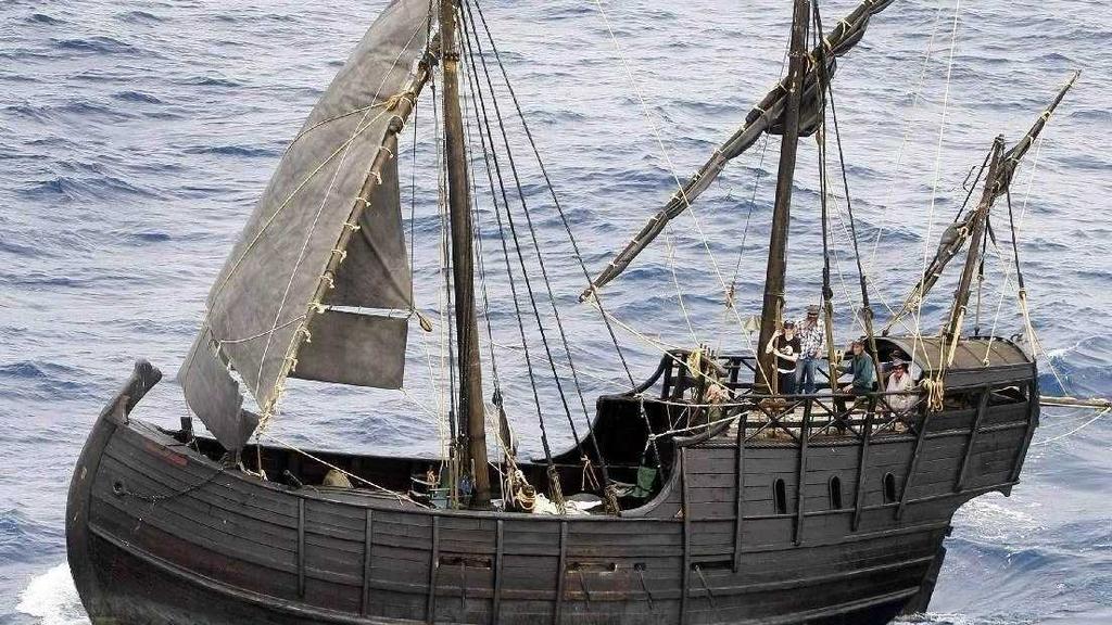
Replica Spanish ship sails into Gladstone
INTRODUCTION by Rex Woodmore
Tantalizingly close to proving the existence & location of the famous 'Mahogany' ship, Rob Simpson's research and his great video, impressed me so much that I just had to offer him his own page here on Oztreasure.
One story of the Mahogony Ship story was included in The Book of the Bush by George Dunderdale, in 1898:
“ January, 1836, Captain Smith, who was in charge of the whaling station at Port Fairy, went with two men, named Wilson and Gibbs, in a whale boat to the islands near Warrnambool, to look for seal. They… found the mouth of the river Hopkins. In trying to land there, their boat capsized in the surf... [They] succeeded in reaching the shore naked, and they travelled back along the coast to Port Fairy..
|
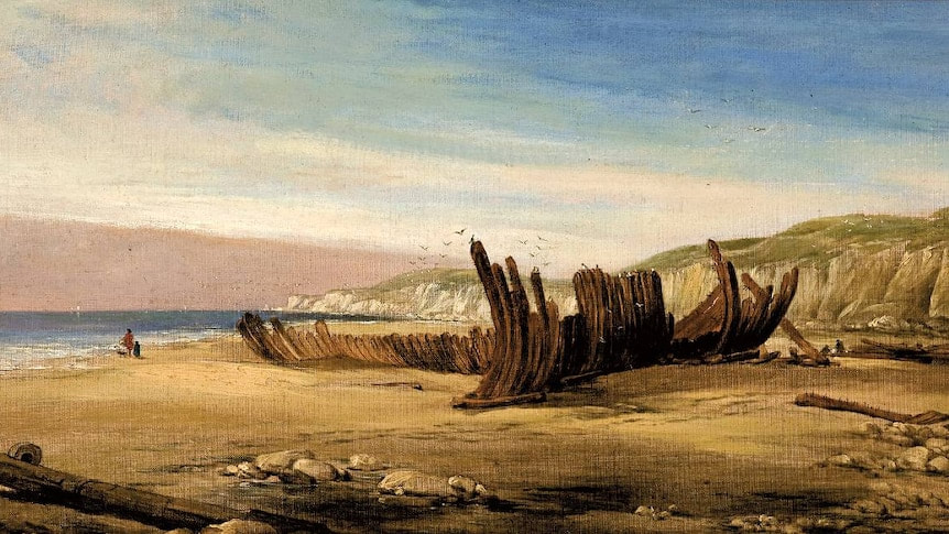
On this journey they found the wreck of a vessel, supposed to be a Spanish one, which has since been covered by the drifting sand. When Captain Mills was afterwards harbour master at Belfast, he took the bearings of it…. Vain search was made for it many years afterwards in the hope that it was a Spanish galleon laden with doubloons.”
|
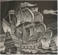
Spanish Galleon
|
THE SEARCH BEGAN
1880's
Since the 1880s there have been about 180 serious claims that parts of the wreck have been found. The Mahogany Ship Committee tests every piece of wreckage that it receives, but drift wood is an unreliable narrator. “What we need is the ship that the wood comes from,” says Connelly. “We’re still searching.”
And searches continue, undeterred. Amateur archaeologist Robert Simpson was the first to use satellite imagery in the hunt for the elusive wreck. On Google Earth, Simpson spotted several unnatural formations in the Warrnambool dunes. “I could see … the outline of man-made objects that were symmetrical,” says Simpson, who believes that the “Mahogany Ship” is a collective term for multiple shipwrecks of unknown origin. Ground-penetrating radar seemed to confirm his theory, detecting strange anomalies deep under the sand, and led Simpson to conclude that he had identified three previously undiscovered inland shipwrecks.
And searches continue, undeterred. Amateur archaeologist Robert Simpson was the first to use satellite imagery in the hunt for the elusive wreck. On Google Earth, Simpson spotted several unnatural formations in the Warrnambool dunes. “I could see … the outline of man-made objects that were symmetrical,” says Simpson, who believes that the “Mahogany Ship” is a collective term for multiple shipwrecks of unknown origin. Ground-penetrating radar seemed to confirm his theory, detecting strange anomalies deep under the sand, and led Simpson to conclude that he had identified three previously undiscovered inland shipwrecks.
An Historical Will o' the Wisp
The Argus (Melbourne, Vic.
Sat 24 Feb 1934
An Historical Will o' the Wisp
THE WARRNAMBOOL GALLEON By J. B. COOKS
THE tradition that a Spanish ship was wrecked half-way between Warrnambool and Port Fairy in the 17th century is a recurring statement in the history of the early days of the Western district. Old suggestions are being revived in view of the Centenary that the sand dunes should be explored in an attempt to discover the buried wreck.
The "Spanish 17th century mahogany ship" has formed the subject of many speculative newspaper articles, columns of correspondence, and lectures
before members of historical and geographical societies. The galleon of romantic dreams is, in fact, a wrecked, or abandoned, flat-bottomed whaling punt, such as was in use by John Griffiths, the pioneer of Port Fairy, who had his whaling establishment on Griffiths and Rabbit islands, in the years of the early forties.
Henry Kingsley, in his Australian novel, "Recollections of Geoffrey Hamlyn," was the romancer who suggested that the old punt, lying half-buried in the sands, was perhaps a Dutch or Spanish vessel. He did so to add picturesqueness to his prose.
In the now rare history of Port Fairy, by Earle — a copy of which the Melbourne Public Library would be glad to obtain — Earle states:— "It was Captain Mason who personally informed Kingsley of the existence of the wreck, one of the old flat-bottomed punts, built
by the whaling parties here in the forties, one evening while strolling along the old jetty. Kingsley there received, in the presence of the late Captain Lewis Grant and others, the inspiration to make a 'Spanish mahogany ship' out of the old whaling punt lying beyond Armstrong's Bay."
The remains of the wreck of the punt have been seen, owing to the shifting of sand in the dunes, over periods extending from 1836 to 1911. Whalers in 1836 knew the situation of the wrecked punt, and there is ample evidence to show that will o' the wisp sights of the wreck hidden in the sand dunes have been frequent. A Spanish coin found at Hamilton was alleged to have been taken from the wreck by an aborigine. Another story multiplied the one coin into a discovery of Spanish and Dutch coins dated 1717, 1792 and 1802. When a "Spanish rapier" was dredged from the River Moyne those
who were skeptical concerning the existence of the mahogany ship were dumbfounded by the production of the rapier, but only for a few days. The "Spanish rapier" was declared, after a close examination, to be a modern English sword.
Captain Cowtan, of Port Fairy, claimed the sword as one he had lost from aboard his ship, in the Moyne, in 1842 or 1843.
The wreck was reported in 1911 to be copper bottomed, and her name was deciphered as being Safrina. After this remarkable discovery she was allowed to slip back into the oblivion of the wind driven sands. If the wreck was as stated,"copper-bottomed," then the vessel probably dated from the 18th century, since it was then that the custom of copperbottoming vessels was first practised. The Commonwealth archivist, the late Mr.E. A. Petherick, pulling a bow at a picturesque venture, suggested that the wreck might be the remains of a Spanish vessel the Santa Anna, or the Santa Maria, captured off Mexico and afterward employed in the whaling industry. She sailed from Sydney in 1811 or 1812, and was not heard of again. Mexico is close enough, as ocean sailing measures, to America, for the Santa Anna, sister ship to the Santa Maria, to have had a touch of Columbus in her timbers, for it was in the Santa Maria that he made his voyage to the New World. Once that is admitted the field for romantic propaganda is wide and fruitful.
MYSTERY WRECK
From Ancient China ?
Wilmington Morning Star February 7, 1992
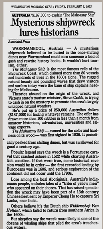
MYSTERY WRECK
From Ancient China ? (I wish!)
ACTIVITY IN RECENT YEARS
1992: the State Government of Victoria offered a $250,000 reward to anyone who could locate the Mahogany Shipwreck. The offer was withdrawn in 1993.
1999: Des Williams discovered wood fragments buried in the sand dunes in the area. But they were White Oak, as used in the US & Europe ship building but not a Mahogany coloured timber. Perhaps from yet another wreck.
2004: An extensive search was done with drills to a depth of 10 metres.
2011: To try to locate the vessel Rob Simpson used old accounts, such as the Alexander Rollo expedition in the19th century.He also used Google Earth to identify what seems to be a clear correlation between the coordinates and the outline of a ship beneath the sand. The area is Armstrong Bay east of Gorman's Road (formerly Lane) and west of Levy's Point near Dennington.
2011: A replica caravel inspired by the Mahogany Ship, launched at Port Fairy
2017: The mysterious mahogany ship
Ghost on the sea.
|
|
2017 YouTube
►.The history of the maritime world contains a lot of mysteries about ghost ships, mysterious missing ships. There are stories that have found the answer, but still more to this day still make an unexplained mystery. |
2018: Josh Gates Expedition Unknown.
"This is a piece of the wreck.
Perhaps it is the Mahogany Shipwreck?
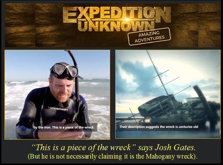
Josh Gates Mahogany Shipwreck. With a piece of a shipwreck
MAHOGANY SHIP & $MILLIONS in GOLD?
#BuriedShipwreck, #Shipinthe sand, #Shipwreck, #SandDunes, #MahoganyShip, #MarineArchaeology, #SearchingBeaches,#BuriedTreasure, #Warrnambool
|
Mahogany Ship Archaeology
(Scroll down if you want to read earlier info preceeding this update) |
Mahogany Ship legend- Fake news?
|
Rob Simpson's Warrnambool Shipwreck Sites
Reproduced with Rob Simpson's permission 5th May 2017
Site 1 and Site 2
There are two sites between the Australian towns of Warrnambool and Port Fairy that I feel are worthy of archaeological investigation.
Site 1 is in the hummocks (sand dunes) half way between Gormans Lane and The Cutting (an inlet from the sea to an inland lake). My reasoning is explained in the documentary Quest for the Mahogany Ship.
Site 2 is in the hummocks one kilometre (.62 of a mile) east of The Cutting. Click on this link to see a very short video of the site.
In my opinion "The Mahogany Ship" is a popular collective title for several shipwrecks stranded in the Warrnambool hummocks that were observed in the nineteenth century. Witnesses didn't report that they were constructed of mahogany, but several mentioned the colour of mahogany. The Mahogany Ship is therefore probably not merely one shipwreck, but several shipwrecks that were stranded inland, and they were unlikely to have been built of mahogany. However I am not suggesting that the term "The Mahogany Ship" should be abandoned.
Reading academically reputable books about the Mahogany Ship makes it clear that there were probably at least three shipwrecks in the 11 kilometre wide hummocks area. All were covered by windblown sand and lost by the late nineteenth century.
Discovery of Site 2
I discovered Site 2 on 18-01-09. I was accompanied by my son James. I was immediately struck by the obvious symmetry of the large complex of sand and grass covered shapes looming above ground level. They are unlikely to have been created by nature. This was reinforced by further investigation.
On 19-01-09 I returned with my camera and made the video.
Aerial archaeology using Google Earth
|
For this purpose I don't use Google Maps which is for finding streets. It is much better to use the Google Earth program – free online. The faint outline of the structure can be seen on Google Earth. I have drawn yellow lines for clarification. |
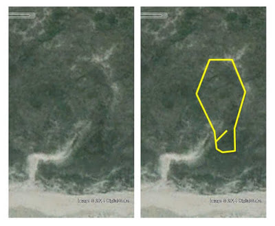
|
It is not the familiar shape of a ship, but it is symmetrical. The image is quite typical of traces of buried structures found by this method. See the many articles about aerial archaeology online. Aerial archaeology is not to be confused with mere aerial photography which is taking photos from the air of objects that are completely recognisable at ground level, such as buildings or archaeological sites that have already been excavated.
The centre of the object, according to Google Earth, is at 38°21'05.17" S, 142°22'47.86" E.
Once found, click on View/Historical Imagery and slide the pointer to the extreme left. This gives an image made in 2004.
Drought and aerial imagery
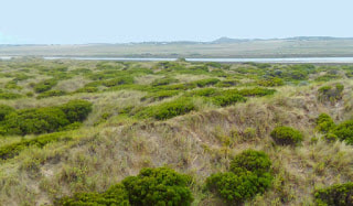
I have now realised why it may be that the older aerial images of both sites show the outlines of the buried objects more clearly. Much more vegetation covers the sites now than in 2004. Certainly, comparing my 2009 movies with my 2015 movies taken at identical places makes it very clear that there is a much thicker covering of vegetation in 2015.
There is a Wikipedia article called 2000s Australian Droughtat http://en.wikipedia.org/wiki/2000s_Australian_drought
It says: "By 1995 the drought had spread to many parts of Australia and by 2003 was recognised as the worst on record."
In my opinion the 2004 images on Google Earth show more sand and therefore the outlines of what might be concealed beneath; and the more recent images show the vegetation that has grown since and covered the sand.
I am not dismayed that the more recent images don’t show the outlines and that the older images do. Different conditions, lighting and methods of photography can give quite contrasting results.
Matching of the shapes with the Google Earth outline
I visited it again on 30-10-14 with an associate. The object was to ascertain whether the outline that can be seen on Google Earth does in fact match the striking geometrical shapes that can be seen on the landscape. We used three different GPS devices – all of which gave similar results. We found that the shapes are indeed in the same place as the Google Earth outline.
Investigation of geometrical alignment
The associate and I returned on 1-11-14 to investigate whether the northern and southern sections are in geometric alignment and therefore might be two parts of one object. It is difficult to judge from the side (where the video was shot) because a hummock seems to have formed over the centre of the object. However standing on the hummock makes it possible to view the two visible sections on either side. Their alignment strongly suggests that they are sections of one large object.
I also took more photos and movies – particularly of Tower Hill in the distance.
Measurement of length
The associate and I visited it again on 15-4-15. Our aim was to measure the shapes – particularly to see whether the length is 180 feet as on Google Earth. This was confirmed, although the ruggedness of the terrain made measuring difficult. I do not claim that the measuring exercise is necessarily perfectly accurate - given the wildly undulating topography.
We returned on 16-4-15 to take more movie clips and photos. I noticed something that had not been obvious before – that there is in fact a symmetrical prow shape (covered in sand and vegetation) where a prow appears to be lacking on the Google Earth outline. The "prow" was measured as 20 feet long.
Therefore, as best as it is possible to gauge, the shape is about 200 feet long if the hypothetical prow is included. We did not measure the width due to the sheer difficulty of working there. But measuring it on Google Earth, the width at the widest point is about 100 feet.
The vessel seems to be unexpectedly large – but then fact has a way of being stranger than fiction!
Near the south end an irregular feature can be seen within the structure. It gives the impression that a large mast has fallen across the object on an angle. It can also be seen clearly on Google Earth. However I am not prepared to claim that it is a buried mast without proper evidence.
19th Century anecdotal evidence – Mrs Manifold
Mrs Manifold's evidence about the Mahogany Ship says (among other things) that it was "strangely designed and constructed". This evidence is second hand and relayed through others. Different versions of it appear in various books about the Mahogany Ship.
19th Century anecdotal evidence – Mr Mason
Mr Mason's evidence includes the information that "her general appearance bespoke a very slight acquaintance of the builder with marine architecture". Both of these witnesses therefore claimed that the vessel they saw was not shaped like a normal ship.
19th Century anecdotal evidence – Captain Mills
It is compatible with the famous and often repeated evidence of Captain Mills:
Well to the eastward of Gorman's Lane. Proceed eastward along the beach till you bring the point of land on which the old iron church stood in line with the highest point of Tower Hill Island. The wreck would be almost in a straight line with those objects, well in the hummocks.
The centre of the object, according to Google Earth, is at 38°21'05.17" S, 142°22'47.86" E.
Once found, click on View/Historical Imagery and slide the pointer to the extreme left. This gives an image made in 2004.
Drought and aerial imagery
I have now realised why it may be that the older aerial images of both sites show the outlines of the buried objects more clearly. Much more vegetation covers the sites now than in 2004. Certainly, comparing my 2009 movies with my 2015 movies taken at identical places makes it very clear that there is a much thicker covering of vegetation in 2015.
There is a Wikipedia article called 2000s Australian Droughtat http://en.wikipedia.org/wiki/2000s_Australian_drought
It says: "By 1995 the drought had spread to many parts of Australia and by 2003 was recognised as the worst on record."
In my opinion the 2004 images on Google Earth show more sand and therefore the outlines of what might be concealed beneath; and the more recent images show the vegetation that has grown since and covered the sand.
I am not dismayed that the more recent images don’t show the outlines and that the older images do. Different conditions, lighting and methods of photography can give quite contrasting results.
Matching of the shapes with the Google Earth outline
I visited it again on 30-10-14 with an associate. The object was to ascertain whether the outline that can be seen on Google Earth does in fact match the striking geometrical shapes that can be seen on the landscape. We used three different GPS devices – all of which gave similar results. We found that the shapes are indeed in the same place as the Google Earth outline.
Investigation of geometrical alignment
The associate and I returned on 1-11-14 to investigate whether the northern and southern sections are in geometric alignment and therefore might be two parts of one object. It is difficult to judge from the side (where the video was shot) because a hummock seems to have formed over the centre of the object. However standing on the hummock makes it possible to view the two visible sections on either side. Their alignment strongly suggests that they are sections of one large object.
I also took more photos and movies – particularly of Tower Hill in the distance.
Measurement of length
The associate and I visited it again on 15-4-15. Our aim was to measure the shapes – particularly to see whether the length is 180 feet as on Google Earth. This was confirmed, although the ruggedness of the terrain made measuring difficult. I do not claim that the measuring exercise is necessarily perfectly accurate - given the wildly undulating topography.
We returned on 16-4-15 to take more movie clips and photos. I noticed something that had not been obvious before – that there is in fact a symmetrical prow shape (covered in sand and vegetation) where a prow appears to be lacking on the Google Earth outline. The "prow" was measured as 20 feet long.
Therefore, as best as it is possible to gauge, the shape is about 200 feet long if the hypothetical prow is included. We did not measure the width due to the sheer difficulty of working there. But measuring it on Google Earth, the width at the widest point is about 100 feet.
The vessel seems to be unexpectedly large – but then fact has a way of being stranger than fiction!
Near the south end an irregular feature can be seen within the structure. It gives the impression that a large mast has fallen across the object on an angle. It can also be seen clearly on Google Earth. However I am not prepared to claim that it is a buried mast without proper evidence.
19th Century anecdotal evidence – Mrs Manifold
Mrs Manifold's evidence about the Mahogany Ship says (among other things) that it was "strangely designed and constructed". This evidence is second hand and relayed through others. Different versions of it appear in various books about the Mahogany Ship.
19th Century anecdotal evidence – Mr Mason
Mr Mason's evidence includes the information that "her general appearance bespoke a very slight acquaintance of the builder with marine architecture". Both of these witnesses therefore claimed that the vessel they saw was not shaped like a normal ship.
19th Century anecdotal evidence – Captain Mills
It is compatible with the famous and often repeated evidence of Captain Mills:
Well to the eastward of Gorman's Lane. Proceed eastward along the beach till you bring the point of land on which the old iron church stood in line with the highest point of Tower Hill Island. The wreck would be almost in a straight line with those objects, well in the hummocks.
|
The innocent sounding word "almost" suddenly becomes crucial – it is in fact almost in a straight line with those objects as my photos and movie clips show! A sighting that is truly in line with those objects ends about three kilometres to the east – where it is much more difficult to see them.
|
It seems unlikely that Captain Mills intended one to proceed along the beach that far! Please note that the Mills evidence is second hand and relayed through a contemporary acquaintance. It is to be found without variation in many books about the Mahogany Ship.
|
Tower Hill from the site. The old iron church was just to the right of the peak. It is sometimes called "Tower Hill Island" because it is nearly surrounded by lakes - not because it is in the sea.
|
|
19th Century anecdotal evidence – Mr Saul and his son
It is quite possibly compatible with the Saul's fence evidence.
A letter from Saul's son on 28th April 1909 states: I cannot give you the exact time, but I think it must be 40 years ago, he erected a fence for the Warrnambool Borough Council across the hummocks, about three-quarters of a mile east of Gorman's Lane. When he came home after completing the contract he informed me that he came across an old wreck high up in the hummocks, and I believe he said it was to the eastward of the fence but I cannot say the exact distance. It was within a half mile of the fence and nearly buried in the sand. "About three-quarters of a mile" plus "within half a mile" is about 1.25 miles or less. According to the Google Earth ruler, the site is 1.28 miles east of Gormans Lane. The vagueness of the evidence makes it possible that this could be the object that Mr Saul saw – perhaps from a distance and without using an accurate method of measurement. If it was "nearly buried in the sand" by about 1869, whatever is left could be deeply buried by now.
The Lieutenant Stanley Locality Plan of 1872
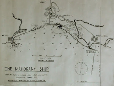
|
The site is in the same place as the black cross on the Lieutenant Stanley Locality Plan of 1872 that appears in books about the Mahogany Ship. It is a hand drawn map, so of course the details are not absolutely precise. The map bears the inscription: The Mahogany Ship |
ABOVE: Locality Plan, enlarged from Lieutenant Stanley's Admiralty Chart, 1872 Approximate position of wreck marked X
A line has been drawn from the highest point of Tower Hill Island to the cross. The line almost transects the point of land on which the old iron church stood. (I have altered the cross to make it larger as it was rather lost in other features of the drawing when the size of the picture was reduced.)
Conclusion
I believe that the symmetrical shapes above ground level are likely to have built up over a human made object. Surely it would be a seagoing vessel – although it is not the usual shape of a ship. There is anecdotal evidence that people in the nineteenth century saw a shipwreck of unfamiliar design in the Warrnambool hummocks.
In my opinion the site is worthy of archaeological investigation. I cannot, of course, judge how much of the original object might survive today. In my opinion (and in the opinions of my supporters) action should be taken to prevent further deterioration.
RECENT INVESTIGATIONS October 25, 2016 – Ground-penetrating radar
A GPR company scanned the site, assisted by some associates. The exercise was difficult to conduct due to the extreme ruggedness of the territory. With such a large site, it was not possible to scan in fine detail during one day. The equipment was dragged and pushed - with difficulty - over the shapes. This was done in lines several metres apart.
There are no results for the northern section due to technical issues.
Seventeen objects were detected under the surface on or near the southern half at a shallow depth of about one to two metres. Deeper investigation was not attempted.
It was not possible to understand the nature of the objects.
I am very grateful to all who helped.
February 15, 2017 investigation with a 2 metre archaeology probe
The associate and I returned with a GPS device and an archaeology probe to try to find the objects. I had entered the latitude and longitude of each object into the GPS device. The device can then recreate the position – but not always with perfect accuracy. We also had marking stakes.
We were unable to find anything. The exercise was not aided by the extremely rugged territory, unpredictable heat and very strong winds. The probe got stuck in the hard sand with monotonous regularity. I returned exhausted and overheated, and had to go to a local hotel for a giant ice-cream sundae!
February 16, 2017 – more investigation with the archaeology probe
Weather conditions were not a problem. We continued to try to find the objects but were unable to do so. At the end we did find something that seemed to be wood rather than metal or rock nearly a metre below the sand – but were too exhausted to dig by then. It was not at a coordinate found by the GPR. It might only be compact sand.
March 16, 2017 – more investigation with the archaeology probe and an auger
The auger consists of half a dozen extensions, each about 1½ metres long.
The associate and I went to the site intending to drill some deep auger holes. But unfortunately, that was not to eventuate. It was a very windy day, making negotiating the site more difficult than usual. The sand was blowing to the extent that in some places it looked like snow on the vegetation.
We spent a long time pushing the archaeology probe into the ground, with the idea that if we couldn’t find something at two metres, the work of putting in deep auger holes might be self-defeating. Despite doing a lot of work with the two metre probe, nothing seemed to be touched. This could be because any remains of an object would be deeper than two metres. It seems that all we have found is very compact sand. As usual, the probe kept getting stuck.
Eventually, unable to get any clues from the probe, we decided to try the auger. It took some time to decide on a likely place to start. The site is about 1,000 square metres.
Using the auger was tough going indeed as the sand is very compact and the auger kept getting stuck all the time. Progress was unexpectedly slow and we only managed to make one auger hole that was two metres deep.
In the near future
An associate is going to modify an auger bit to make it more effective in very hard sand. We will then try again.
We know, from the GPR equipment readings, that the site is at least 12 metres above sea level, and somewhat higher than that in some places. We also know that up to 15 metres of sand has blown onto the Warrnambool hummocks since European settlement, because European snail shells have been found at that depth. We also know that plastic – invented in the 20th century – has been found more than 3 metres below the sand in the same vicinity as the site. It seems likely that any remains of a seagoing vessel would be found at a deeper level than two metres. We can conclude that investigation at a deeper level is now needed, using a modified auger bit. Rob Simpson
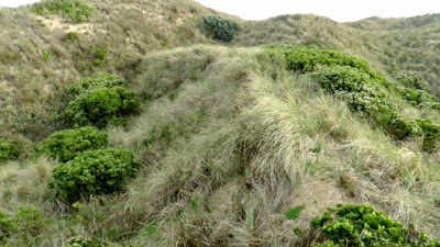
|
RIGHT: The west arm. It disappears into a hummock.
I do not believe that sand dunes form at random in the shape of the symmetrical ribs of a sailing ship. |
|
|
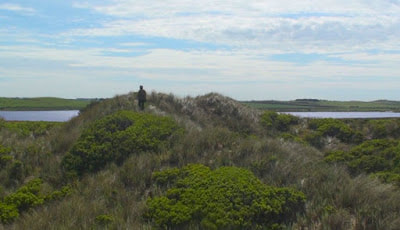
LEFT: Standing on the same arm, taken from the south
after the site became more overgrown with vegetation. |
|
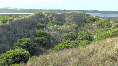
RIGHT: I cannot believe that such symmetry occurs
naturally in sand dunes. The arm on the left is the same arm as in the previous two photos. |
|
|
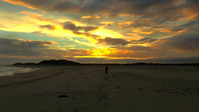
LEFT: Walking into a Warrnambool sunset after a day at the site.
|
ABC South West Victoria 19 May, 2011 10:32AM AEST
Is this the hiding place of the Mahogany ship?
By Jeremy Lee http://www.abc.net.au/local/photos/2011/05/19/3220977.htm
AUDIO: Rob Simpson talks about his search for the Mahogany ship
Is this the hiding place of the Mahogany ship?
By Jeremy Lee http://www.abc.net.au/local/photos/2011/05/19/3220977.htm
AUDIO: Rob Simpson talks about his search for the Mahogany ship
MYSTERY OF A BURIED SHIPWRECK ALMOST SOLVED?
The “Mahogany Ship” is one of Australia’s most intriguing and enduring shipwreck mysteries.
In 1836, two survivors of a capsized whaling boat reported sighting a large shipwreck in sand dunes between Warrnambool and Port Fairy. Shipwrecks were not unusual in the area at the time, but the reported construction of dark timber, possibly mahogany, and the ship’s hull design were vastly different from the vessels which sailed the local waters in the early 19th century.
More than 30 other accounts of the wreck were recorded until the 1880s.
Many people at the time, and since, believe the wreck to be a Dutch or Portuguese exploration ship from the 1500s.
Many others believe it is nothing more than an interesting local legend, as there have been no reported sightings since the 1880s and, in fact, no solid evidence of the wreck at all.
ROB SIMPSON'S QUEST THE MAHOGANY SHIP
With his brilliant research & detective work, I think Rob Simpson has hit the nail on the head. Let's hope the nail is handmade & in Mahogany!
|
|
|
QUEST FOR THE MAHOGANY SHIP by Rob Simpson
I have been going to Warrnambool all my life and have often taken my family there for holidays.
It has been possible to use the existing literature about the Mahogany Ship mystery to find the exact position of large buried shipwreck inland near Warrnambool. The concept becomes even more convincing when the technique of aerial archaeology is added. However there is a huge covering of sand at the site. So far it has not been possible to prove the theory with tangible evidence as I am not an archaeologist and these days you are not allowed to dig. Ground penetrating radar doesn't work well at the site because of the salt in the sand.
My video Quest for the Mahogany Ship unfolds the literary and aerial evidence for the site. I was helped with the movie in all sorts of ways by my family and friends, so have many people to thank for their contributions.
I would like to see the remains of the shipwreck investigated by archaeologists.
BRIEF BIOGRAPHY Rob Simpson
 Rob Simpson
Rob Simpson is the Author of a book that teaches natural typing without repetitive strain.
Interests include history, archaeology & psychology.
http://www.rsifree.com/
Interests include history, archaeology & psychology.
http://www.rsifree.com/
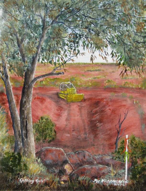
Getting Gold by Rex Woodmore
|

Rex Woodmore
|
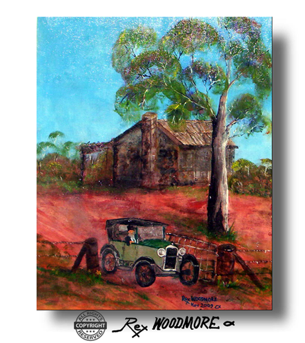
Prosperous Pastoralist by Rex Woodmore
|

Email Rex Woodmore: [email protected]
